

It was mid August and I had the urge to find a solid mountaineering climb in the Sierra Nevada range of California. With so many options I researched some of the classic climbs and came across Mount Ruskin on a website, which was noted as one climber’s top ten climbs. The name was familiar to me. My neighbor Dan explained, that as a child he hiked Mt. Ruskin with his father. It was his father’s favorite climb. Dan explained his father loved it so much that his dying request was to have his ashes spread on the summit, which Dan fulfilled for him in 2016.
Mt Ruskin stands at 12,920ft and is located over the upper limits of the wild South Fork Kings River Valley. The Sierra Club’s, Sierra Peaks Section, rated it as one of the 35 “Mountaineers Peaks”. Although it is not the most prominent peak in the region, the Sharply defined ridges identify Ruskin as a worthy climb. I decided I would take the western approach over Taboose pass and climb Ruskin’s east ridge.
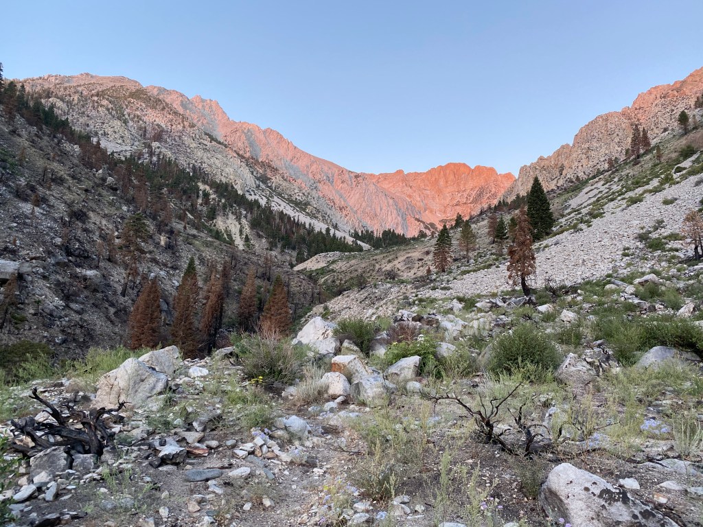
The road past the turnoff for Taboose Creek Campground is rocky, rough, and unmaintained. It requires a high clearance vehicle and personally 4×4 unless your pretty ballsy. The rough rocky road was slow going and took about an hour. Once at the trailhead I set up my air mattress and sleeping bag in the back of my truck and jumped in as the sun set and darkness creeped across the sky. The sound of the river close by lulled me to sleep. At 4:00AM I woke after a good night’s sleep. By 4:45 I was off and heading towards my 1st goal, the eight mile climb up Taboose Pass. The pass started at and elevation of 5,400’ and would top out at 11,400’. That’s 6,000 feet of elevation gain. The trail was sandy as I gradually climbed into the narrowing pass. My headlamp and the faint glow of a waxing crescent moon was all the light that I needed. Within an hour, an increasing sunlight shinned from the mountains behind me. As the sun climbed it gave more shape and form to the land beyond my headlamp. The trail dipped down by the creek and I saw something thirty yards away sprinting up the hillside. It was a black bear. This was the first bear I’ve even encountered in my eleven years of hiking in the Sierras. I’ve always wondered how I would react to a bear encounter, and I was soon to find out. I stopped and watch the bear running up the hillside. I wasn’t freighted like I thought I might have been. The bear was beautiful, and a part of this natural splendor. I was happy to share the moment with such an creature. Soon the bear scrambled up the slope and disappeared over a ridge. Now out of sight, I hiked on.
Soon the sun came over the mountain range to the east and the rocks, trees and trail below my feet emanated a warm golden glow. The trail began rising sharply as it switchbacked up the pass, in and out of patches of thick forest and across small streams. I noticed I still had cellular service on my phone, but I was now down to one bar. I texted my girlfriend Leira, for one last goodbye before the signal was lost. I did manage to get a response, and a one last “gook luck” from her. The trees now thinned out, and rocks, boulders and bare scree slopes somewhat obstructed the pass. Waterfalls cascaded down the center of the pass and the sounds of their gentle flow filled the air. I decided to listen to my audio playlist that I had made for the trip.My choice wasn’t music but rather inspirational speeches on YouTube. I had a long way to go and the spoken words motivated me and enabled me to focus as I slogged through challenging terrain.
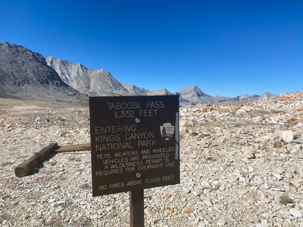
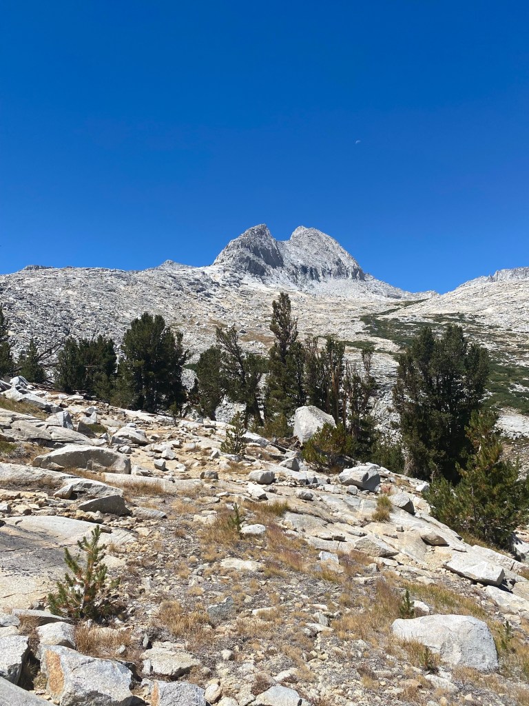
The top of the pass soon came into view. It was wide, and blue sky filled the gaps between the mountains on each side. It took five hours to gain the top of the pass. Before me now appeared a downward sloping vista of grass, streams, rocks, and conifer trees that highlighted the valley before me. Rocky peaks rose along the horizon out of green valleys. Mt. Ruskin finally came into view, far off to the right of the pass. I then hiked down a beautiful trail which cut through green mountain meadows. I had three miles to hike before the trail intersected with the Pacific Crest Trail (PCT). After about two miles, I decided it was time to stash my bivouac sac and sleeping bag before pressing on for the summit. This would lighten the load and enable me to move more quickly as I approached. I then walked off trail where I found a grove of small conifer trees, which looked like an ideal campsite. I hung my stash from a tree, marked the location on my Garmin Fenix watch, and returned back onto the trail. when I was about 0.2 miles on the trail beyond a beautiful flowing stream, I found the perfect campsite with an iconic view of the peaks and valley below. This ideal site is where I would camp.

When I came to the intersection of the PCT trail, I headed north up the trail. Approximately five minutes later, I passed a hiker traveling southbound, who was the first hiker I encountered thus far on the trail. I had not seen any hikers on the Taboose Pass. I also noted there were not any other cars at the trailhead where I parked. But soon I encountered another group of three hikers, followed more groups. I then realized these individuals were backpackers traveling the PCT trail and John Muir Trail, which share certain sections of the trail together. The PCT trail is 2650 miles long encompassing the length of the entire west coast, from the southern boarder of Mexico, to the northern boarder of Canada. The John Muir trail is a 210 mile trail which runs from the Whitney Portal, all the way to the Yosemite Valley. Both trails are very popular among the backpacking community as evident with the thousands of hikers who come each year to enjoy both routes.

As I headed approximately two miles up the PCT trail I constantly consulted my maps, research, and the route I plotted on Gaia, which is a navigation application on my phone that uses GPS and topographic maps to show your exact location. Gaia has served me well and has made navigation easy without a reliance on trail markers. I was now looking for what was supposed to be a “use trail”, or unmaintained trail, that lead up the cirques east of Mt. Ruskin. I had no luck finding it. There was no trail in sight. I then made the decision to just go for it and head westward into the thick woods up the slopes in the direction I suspected the east ridge would be. The terrain was steep, slow, and tough going. I had already been on the trail for twelve miles, and had climbed well over 6,000 feet in elevation. The concentration required to navigate with no trail markers or definitive landmarks, through thick woods, was an exercise in concentration. It proved to be quite stressful. As I continued, the tip of a peak shown through the trees over a ridge. It was the class five blocks that marked the beginning of the east ridge. To see them was a relief, and my hope was now restored, as I hiked on.
The woods now gave way to rock slabs mixed with boulders. A clear line of sight to the ridge laid before me. Although it looked far off, I thought to myself I needed to keep moving forward. Every step up and in a forward direction is progress gained. Soon I was below the east ridge. The ridge gave a monolith appearance as it shot up from the rocky slabs at its base. As per the guidance, I moved to the west of the ridge to find the much easier class 3 chutes to gain the Ridgeline, not being sure how far to go. The guidance on the research I studied about the route was vague and I didn’t want to skirt too far to the west and find myself on the horrific boulder field. I skirted the edge of the ridge looking for signs of cairns or foot prints but with minimal success. This mountain was rarely climbed. The Website Summit Post stated the mountain gets maybe two visits a year. “This looks doable,” I thought to myself. Guessing I found the best spot to begin ascending the cliffs, as I picked a line up the granite rock along ledges and cracks. The holds were plentiful and solid but it felt more like 4th class. Soon the climbing got harder and a few exposed sections felt even more 5th class. I realized I started climbing too early onto the ridge. I skirted my path further north west and eventually came to a less exposed chute. As I scanned the ledges I found a lone Cairn. A cairn is a pile of rocks indicating a trail. But sometimes it ends up not being a trail at all. I thought, “well I’m not the only crazy person to take this route.” Regardless it gave me some relief and I climbed higher. Eventually I came to a point where the upward slope gave way to a sheer drop hundreds of feet straight down. Alas, I attained the ridge and the fun was about to begin.

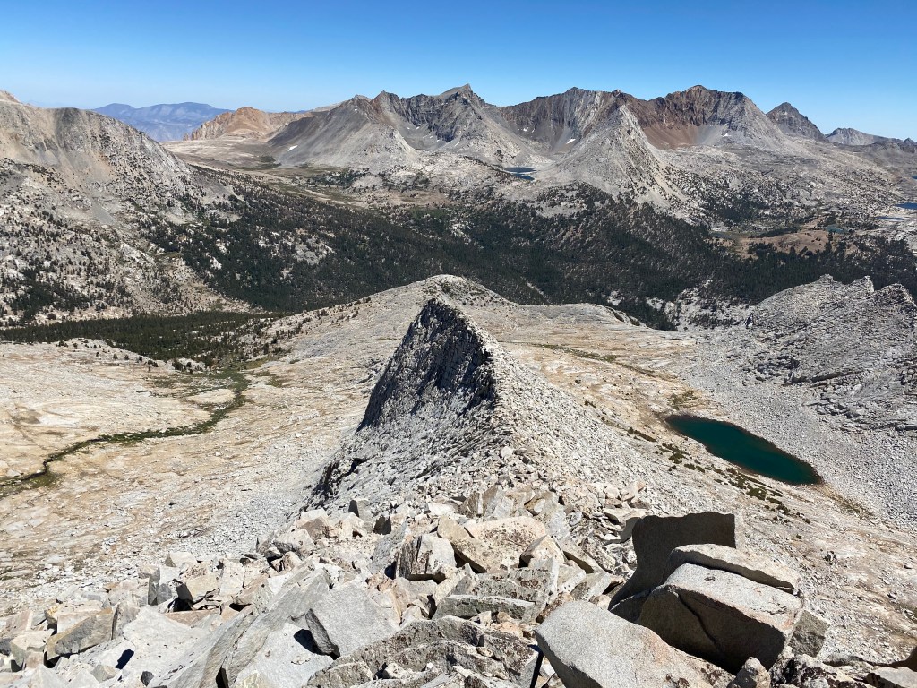
I looked westward and up the sharp narrow ridge line. I saw a definitive spine of boulders, jagged rocks that twisted and turned as it rose to a point high on the horizon. The feeling of an adrenaline rush began to course through my veins. Fatigue and the force of gravity that I had felt pushing me down melted away, and now a feeling of freedom overcame me. A mental focus began to take over, as I became more attentive to the presence of the exposure before me. A fall here could be fatal. I advanced up the narrow ridge line calculating every step and analyzing every rock and hold. It was sheer joy. The exposure presented amazing views of valleys, lakes and mountains in every direction. Within one hour of gaining the ridge I had made it to the peak I was aiming for. It turned out to be a false summit ,but hope was not lost. Beyond the false summit there was a narrow ridge line stretching westward to the true summit. Without much more gain in elevation, I seemed to be gliding along the ridge. One challenging area was easily maneuvered by dropping down onto the north side of the ridge and sliding along a narrow cliff, to circumvent it, then regaining the ridge-line again. After just another fifty yards of scrambling the incline gave way to hundred foot drops on all sides, and nowhere left to ascend. I had succeed, and at 2:58 PM I was at the summit.
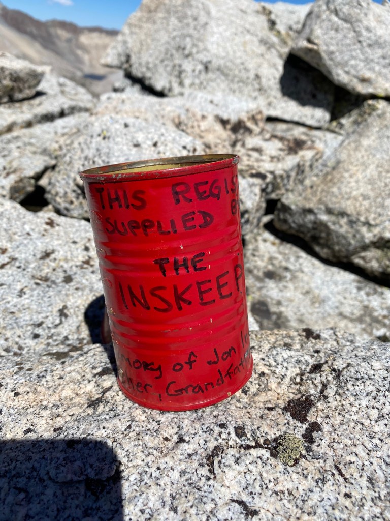
I sat in silence and pure bliss for about twenty minutes listening to the silence before I started planning my descent. The sun was sinking and I had several miles back to where I planned on camping for the night. I wanted to make it there by nightfall. As I headed off the summit and along the ridge I noticed a red tin can. Curious I had a look, and on the can it read, “This register supplied by the Inskeep’s.” It was the can My neighbor Dan and his family used to carry his fathers ashes up to the summit. It was left right where he said they stopped. Inside was a small note pad and pen. I read the signatures and inscriptions from his family members who had made the trip with them. I took a photograph of it for Dan. He was very happy when I showed him the pictures later. I secured the can between some rocks so that it would remain there for years to come, and hiked on.
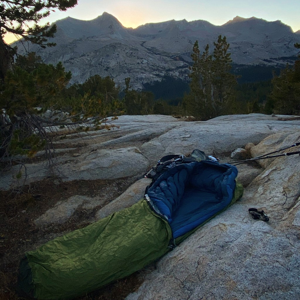
Just past the false summit I found a chute which lead to a talus slope that took me down off the ridge to lake 11500. After grabbing some water, I navigated my way back to the PCT and headed south. By this time I have been hiking for twelve hours and couldn’t wait to get to camp and relax. Once back on the trail, the hiking was easy. A sense of relaxation, calm and accomplishment overcame me after having reached the summit and getting back onto an established trail. This feeling was the result of knowing there will be no more difficult route findings, or questioning if I were to succeed in my summit quest. I slowed my pace and enjoyed the sounds of the rivers, the bird calls, and wind blowing through the trees. By 6:30 PM I was at the camp site where I would bivouac for the evening. I retrieved my gear, filled up my water bag from the nearby stream, ate, and laid down in my sleeping bag. The sun set behind Mt Ruskin, silhouetting the entire vista of mountains lining the horizon. The sky turned from yellow to pink to a deep dark blue, and the stars began to appear. My eyes grew heavy as I drifted off to sleep to the sounds of flowing water from the stream nearby.
The next day I was up at dawn, and began preparing to leave. When I am out in the mountains I seem to get into a saccadic rhythm, falling asleep with nightfall and waking up at sunrise. I packed my things and set off. I had a two mile trek to get up over the pass, then another eight miles down to the trail head. I felt light and fast regardless of the long day before. At the top of the pass, I stopped and looked back, taking one last look into Kings Canyon. The morning sun illuminated the peaks in golden light. I wondered if I would ever come this way again. I soaked in the view on last time, just in case I never return. It was 7:00AM. The trail down Taboose Pass went by in a flash. During the decent, I found I was able to maintain a steady jog down the trail. By 9:45AM I arrived at the trailhead and was shocked by how quickly I made it down. I threw my pack in the back of my truck, put on my flip-flops and drove off. It was another successful trip and it was time to head home.

