
music: “Waves”, Mr. Probz
On July 18th, 2020 I completed the Thunderbolt Traverse along with three other companions, Tony, Lauren, and Ben. This super classic route takes you on a tour of five 14,000ft summits. The great Peter Croft once said; “This traverse is one of the prized jewels of American alpinism. To summit any one of these 14,000-foot peaks is a great thrill and accomplishment, but to string all five of them together is the climb of a lifetime.” I agreed with Mr. Croft.

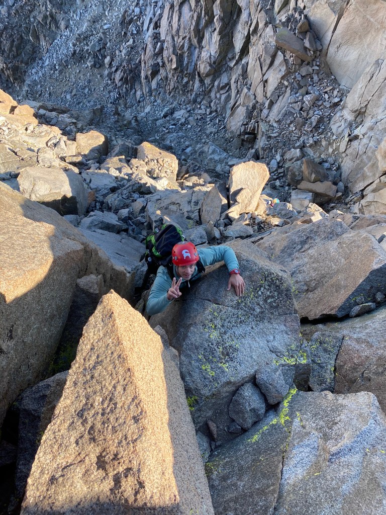
We started by climbing Thunderbolt Peak and took the Southwest Chute #1, which deposits you at the base of the summit block. The summit block involves executing a few exposed moves of 5.9, and is the crux of the entire route. We then down climbed and rappelled a very exposed 4th class route into Underhill Couloir. From there we zig zagged the route up 4th and light 5th class to Starlight Peak.
If you are mainly an on-trail hiker, or not a hiker at all, the concept of different classes of hiking is not intuitive. Classes range from class 1 to class 5. Class 1 would be considered on trail-hiking or gentle terrain. Class 2 would be Scrambling, thus occasionally using your hands. Class 3 is considered typically off-trail hiking where hands and feet are both needed. Class 4 is similar to class 3, but with exposure. Meaning, if you fall you will get very injured. Hand and footholds are still easily found, and technical climbing equipment is not necessarily needed. Class 5 is considered climbing where a fall would be fatal. the Class 5 rating system is further divided from 5.x and in various more difficult grades up to 5.15. Those upper grades can often be sub-divided into a, b, c, and d. the majority of time technical equipment such as ropes, harnesses and traditional protection is used to reduce the risk of a fall.
The route finding along the ridge was intense and just when you thought the route cliffed out, or came to an unclimbable wall you would find a hidden catwalk, or a climbable slope around some extremely exposed corner that you never though to look around. There were barely any cairns on route. Cairns are trail markers composed by stacking rocks on top of each other to indicate the route. Those piles of rocks always gave me that warm and fuzzy feeling when I was on a route. Occasionally you could find a foot print in some dirt that gave you a slight indication you were heading in the right direction, or just as lost as the guy who that footprint belonged to. We depended a lot on diagrams, write-ups and studying the route beforehand. We knew the route finding would be difficult and challenging, and we all came prepared with the knowledge and tools to manage it. On the way up to Starlight I found myself in some of the most exposed climbing I have ever done. I described it to myself, as a place where your dreams and nightmares come together in one epic adventure. I found myself free climbing in sheer bliss. I thought to myself, “I could do this forever.” The combination of the challenge, the beauty, and pushing through the emotional fear to gain that mental focus and attain the summit goal. It brought me the freedom to live truly in the moment.

The summit block of Starlight was the only other place where we belayed off the slings on the top of the summit block. The summit block is called the “Milk Bottle” for it distinct shape, and is rated at 5.6 on the south face, and 5.9 on its north face. Tony did a great job lead climbing it. After, to save time and nerves, the rest of us just top roped it.
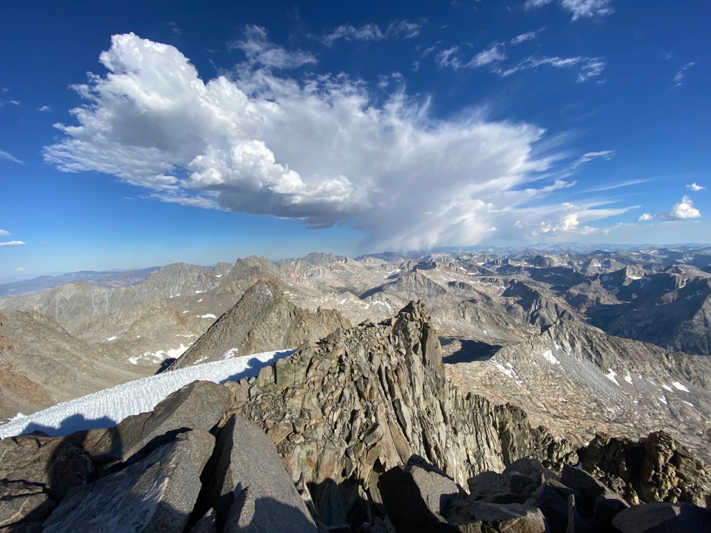
From Starlight we traveled south through a narrow gap and easily found the rappel slings to take down into the gap between Starlight and North Palisade. It took two rappelles to get down into the gap. From there it was another adrenaline filled climb up North Palisade. There was extreme exposure, tough route finding, and 5th class moves over sheer drop-offs that demanded all your focus and concentration. A wrong move could result in a long long fall. After a fifty foot rappel down into a deep notch we had to swing out across onto a massive block sitting on the other side of it. From there we made our way up the north face. We decided to take the 5.5 dihedral to the summit and planned to rope up and lead climb it. When Tony got there he free climbed it without roping up, and the rest of us followed suit. The last move was intense. It incorporated a small dyno move over a thousand plus ft. drop onto the glacier below. The next move was a quick mantle onto a narrow catwalk. With a couple more step we were sitting on the top of North Palisade Peak. It was the highest of the Palisades Traverse and largest we had summited out of the three peaks so far.

From the summit of North Palisade we rappelled and made our way over to the U Notch. From the top of the notch we had two long rappels to reach its bottom. It took some time at the second rappel station to clean the tangled mess of old frayed ropes to make a proper acceptable rappel anchor. We all agreed we could safely rappel off the newly replace rappel slings. With only Polenomium and Sill Peaks left on the traverse, we laughed and joked the hardest part of our adventure was over. But We were wrong. The mountain gods must have heard our disrespect. Heading up to the summit of Polenomium from the U Notch I took a wrong assessment of the route and began climbing towards what I thought was a rappel station on a 5.2 route, that turned out to be a bail-out nut on what was more like 5.10 route! Fortunately, I was able to down climb without incident and Tony found what we determined was the correct route. Instead of a 5.2 easy route, it turned into a 5.6 – 5.7 on an extremely exposed face. After getting to the top of the face there was just a little bit more of a scramble to the summit of Polenomium Peak. With the sun setting fast and thunderstorms in the distance a group decision was made not to summit Mt Sill and to head down the pass between Polenomuin Peak and Mt. Sill. I didn’t mind, nor did Tony since we had already summited Mt. Sill in the past. The other reason we decided against it was because it was an easy class 2 scramble along a ridge over to the summit and we all agreed the most fun and challenging part lay behind us.

The southwest pass down was longer and more technical than expected. With the sun setting faster now and the mountains on the horizon gaining the deep golden, then reddish glow, night would soon engulf us. We trudged down a snowfield and onto flat ground for the first time in over twelve hours. Just when we thought we were home free, our trail cliffed out and again we were forced into some extreme route finding, down a class 3/4 rocky ledge onto another snow field below. By the time we got onto the snow field darkness had fallen and a boulder field laid ahead. With no moon, and only our headlamps route finding was limited and travel was slow. Over the next three hours we hopped over boulders, and consulted with Gaia, a navigation tool on my phone to determine which direction of travel to hike. By 11:30PM we were at the base of Potluck Pass, a wall of cliffs, benches and ledges stood in our path. Our dim headlamps could not find a way over it. A group decision was made to bivouac there for the night. With no moon we were in complete darkness and decided it was better to travel at first light to find our way over the pass and the rest of the route back to camp.
We found a sandy patch with a nicely slanted rock to lay our backs against at the base of the pass to bivouac. Everyone donned all their clothes and found ways to retain as much heat as possible, as the temperature started falling. Tony and Ben even emptied their backpacks and pulled them up over their legs to keep their feet and legs warm. That night temps fell to right around freezing. I realized when I saw thin layers of ice on the streams in the morning. It was a cold uncomfortable night, but we survived and all got some rest. Upon first light we found our way over the pass. What laid before was was two miles of slabs, boulder fields, snow fields, and moraines to get up and over Thunderbolt Pass. Even with the rigorous hiking, it was enjoyable. The hike passed the entire traverse to the east that we had just scaled. Sheer granite walls shot up to the sky and the landscape was littered with massive boulders that appeared to be thrown down from the peaks above. Looking up at the granite spires and deep chutes gouged out between the peaks, I was in awe with what we had just done. Within four hours we were up and over Thunderbolt Pass and in another thirty minutes back down at our camp. After packing up and eating our snacks, it was time to head home. After hiking a little cross country up to Bishop Pass we were back onto a maintained trail. From there our hike out was peaceful. The trail wound around lakes and along the base of peaks on each side. A thunder shower came through and cooled off the mid day heat. There was little talk on the hike out as we all reflected on our epic adventure.

Im really happy you enjoyed it. The was one epic climb and I would do it again in a heartbeat.
Thank you for sharing yours. I never even heard of that place but would love to go there.
Really nice post and seems to be a great traverse! The photo while scrambling along the ridge also looks great! It reminded me a traverse I have done a year ago in Greece.
https://olympusmountaineering.wordpress.com/2019/06/30/traverse-of-arete-of-chelmos-aroania-mountain-pt-02-gardiki-arete-neraidalono-kalavryta-ski-centre/
Thanks for sharing this post.